The Colorado Avalanche Information Center (CAIC) provides weather and avalanche forecasts for the Colorado mountains. Weather events create avalanche conditions, making the weather forecast essential to understanding avalanche forecasts and conditions. Here is a short overview of the CAIC’s weather forecasts to help you use them.
Homepage Forecast:
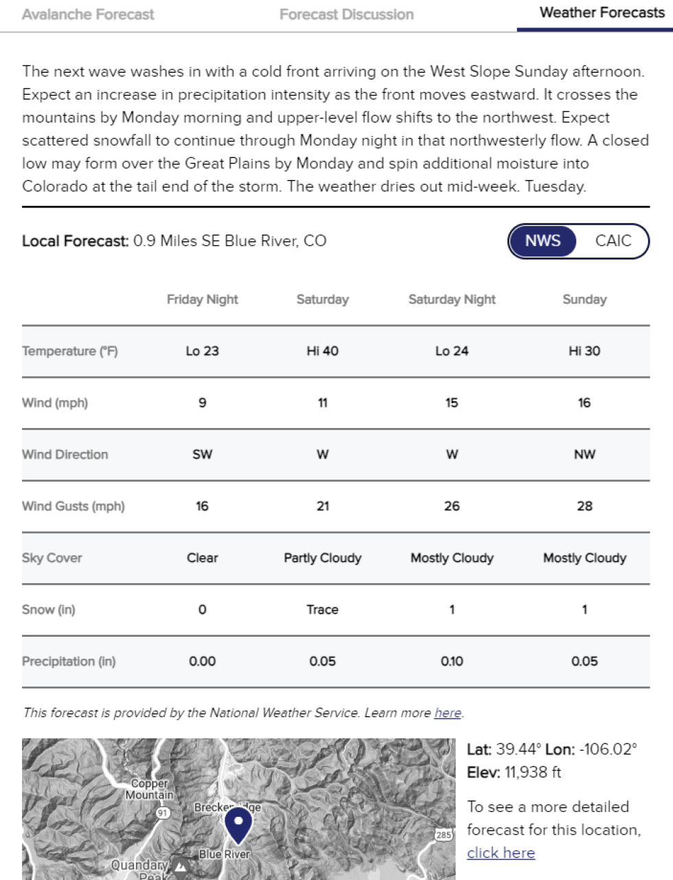
From the homepage, click on the map or type in a place name to open the forecast in a side panel. The forecast panel has three tabs: Avalanche Forecast, Forecast Discussion, and Weather Forecast. In the Weather Forecast tab, you’ll find:
- Weather Summary: A CAIC forecaster issues a summary of the current weather forecast by 6:00 AM and 1:00 PM each day. The summary covers the Colorado mountains over the next 48 hours but focuses on areas or periods where the weather will have an immediate impact on avalanche conditions.
- Weather Forecast Table: The table has a weather forecast for four 12-hour periods (a day is 6:00 AM to 6:00 PM, and a night is 6:00 PM to 6:00 AM). The default forecast is from the National Weather Service (NWS). At the top-right of the table, you can change the forecast source to “CAIC” to see the CAIC’s numerical weather model (CAIC WRF HiRes). You can change the location of your weather forecast by moving the pin in either the homepage map of Colorado or the zoomed-in inset map. To the right of the inset map, you can click a link to get a more detailed (i.e., hourly) forecast from the CAIC’s model for the same location.
Weather Menu:
From the main website menu, look under “Weather” for web pages on both weather forecasts and weather observations.
- Weather Forecast - On this page, you can read the Weather Summary a CAIC forecaster issues a summary of the current weather forecast by 6:00 AM and 1:00 PM each day. The summary covers the Colorado mountains over the next 48 hours but focuses on areas or periods where the weather will have an immediate impact on avalanche conditions. You can also get a detailed point forecast for anywhere in the Western U.S. by selecting a location on the map. These forecasts are from the CAIC’s numerical weather model (CAIC WRF HiRes).
- Forecast Models - On this page, you can find highly technical information, including planer sections and animations from several different weather models. Choose the model, area, and other features at the top and the parameters you want to see in the table.
- Point Forecasts - On this page, you can find weather forecasts for specific locations around the state from several different models. This page has some displays commonly used by meteorologists, like simulated balloon soundings, wind roses, and time-height plots.
- Weather Stations - On this page, you will see weather observations, rather than weather forecasts, from weather stations around Colorado. Use the controls at the top to set the display, and click on the station name to see detailed graphs and tables.
- Snowfall Observations - On this page, you will find how much it snowed in different locations around the state. All of these numbers come from automated weather stations.
Tips for using our weather forecasts
There are entire textbooks about how to use weather forecasts. Our hope is that we can provide you with some basic information that helps you understand and use these forecasts, as well as being a gateway to more information. There is a lot of information available about how these forecasts are created. You can also always write us with questions from our Contact Us page.
- Scale matters - The avalanche forecasts cover large areas, often 1000 square miles or more. The weather forecasts are for a specific point or location. Make sure you click where you are going in the map and then check that location and elevation and adjust as needed to make sure you’re getting the right weather forecast. Or you can search for the specific place you plan to go.
- Elevation matters - The forecast numbers in the table may change dramatically based on the elevation shown next to the inset map. Move your point around to get an elevation that makes sense for where you are going. Weather models use a coarse representation of the terrain, so the elevation of the weather model forecast will always be a little lower than the actual terrain in that area.
- Time matters - Weather forecasts are created by complex computer models. They start with weather observations and then solve a complicated set of equations to predict the weather. The computer solves these equations thousands and thousands of times to create a forecast for different times. The further out the prediction, the greater the chance an error in the initial conditions or in the process grows into a big enough error in the forecast to be important to you. So you should have more confidence in the forecast for the first 12 hours than the last 12 hours.
- NWS Forecasts - These forecasts are created by the National Weather Service and come from their National Digital Forecast Database. These forecasts start from a gridded numerical weather model forecast and are enhanced by human forecasters.
- CAIC Forecasts - These forecasts come from a gridded numerical weather model that the CAIC configures and operates. We use the Weather Research and Forecasting Model (WRF). We run the WRF model in two different grid configurations, both with a large grid over the Western U.S. and a smaller grid over Colorado. The CAIC WRF has a 16km outer grid and a 4km nested grid. The CAIC WRF HiRes has a 6km outer grid and a 2km nested grid. You can read about the configuration of these models and a comparison here.